Svirskaya Guba (Svir Bay, the)
Group name
Topographical landmarks
Mentioned in articles:
|
hidden
|
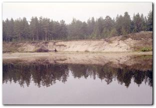
"Nizhnesvirsky", a reserve
The "Nizhnesvirsky" natural reserve is located on the territory of the Lodeynopolskiy District. Its are is 41615 hectares. It was founded on 11 June 1980 on the base of the Nizhnesvirsky reserve. It included the shore and the part of the water... more
|
|
|
|
hidden
|
Svir River, the
SVIR, a river in the north-east of Leningrad Oblast. Length: 224 km. Average flow rate at the mouth: 780 cu. m/s, catchment area: 84,400 sq. km. It flows from Lake Onega at its south-western end, crosses Podporozhye and Lodeynoye Pole Districts, and... more
|
|
|
|
hidden
|
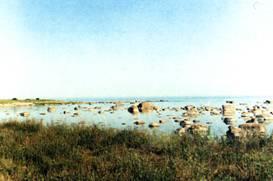
Water - marsh lands
The water - marsh lands (WML; the Ramsar sites is the name of the Ramsarskiye lands(ugodya) in the international classification) . They were founded to protect the waterfowl habitat. The list of 35 lands was registered with the Government... more
|
|
|
|