Articles
/
Volgo-Baltic Waterway, the
Volgo-Baltic Waterway, the
Subject /
Topography/Reservoirs and waterways
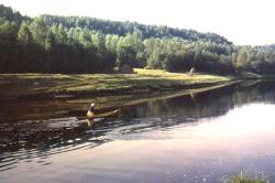
The VOLGO-BALTIC WATERWAY, artificial waterway in the North-West of Russia connecting the Neva River basin with the basins of rivers of the Volga and the Northern Dvina. Its history is traceable back to the Mariyinsky Canal System, the construction of which was started in the late 18th century and the navigation was opened in 1810. The route began at Rybinsk City, and extended via the Sheksna River, Lake Beloye, Kovzha River, Mariyinsky Canal, next via the Vytegra River, Lake Onega, the Svir River, Lake Ladoga, and the Neva River. Length: about 1100 km (Europe’s longest waterway.) The Northern Dvina Canal branching from the Sheksna (opened in 1828) extends via the Sukhona River and Northern Dvina up to the White Sea. For the more safer sailing of small flat-bottomed vessels were built later the bypass canals: Belozersky Canal, Onezhsky Canal, and Novoladozhsky Canal. By the early 20th century this system did not meet the nation’s needs any more. A fundamental reconstruction of VBW was started after WWII and was completed in 1964; at some places the new route deviates from the previous one. The new system has five powerful hydraulic engineering facilities with seven one -track locks. There are four hydraulic engineering facilities at the northern slope: Vytegorsky, Belousovsky, Novinkinsky, and Pakhomovsky arranged at the elevation from Lake Onega to the watershed about 80 m high. The fifth hydraulic engineering facility, Cherepovetsky, is on the southern slope, on the Sheksna River. The depth of VBW is at least 4 m, which enables sailing vessels of tonnage of about 5,000 metric tons. Cargo transportations are mainly provided by self-propelled cargo vessels and sea-river vessels, which move not via bypass channels but directly across the lakes. VBW is also user for passenger services and waterway tours. Permanent bridges are constructed at the intersections of the waterway with railways and motor highways.
Authors
Margolis, Aleksandr Davidovich
Geography
Topographical landmarks/Ladoga Lake
Topographical landmarks/Mariyinskaya Canal System
Topographical landmarks/Neva River, the
Topographical landmarks/Novoladozhsky Canal, the
Topographical landmarks/Onega Lake
Topographical landmarks/Onezhsky Encircling Canal, the
Topographical landmarks/Svir River, the
Bibliography
Стромилова Е. Н., Славина И. И., Манкуни Г. Г. Волго-Балт с борта теплохода. Л., 1984.
Егорьева А.В. Волго-Балтийский водный путь. Л., 1966
Mentioned in articles:
|
hidden
|
Drainage network
HYDROGRAPHIC NETWORK. Over 19500 rivers and 1800 lakes (Ladoga and Onega being the largest ones) form the H. N. of the Leningrad Oblast. The river network is dense and ramified. One exception is the Izhora Hills where the river network density is... more
|
|
|
|
hidden
|
Lodeynoye Pole District
LODEYNOYE POLE DISTRICT, a part of Leningrad Oblast located east of Lake Ladoga in the Svir River basin. In the north-west and north, it borders Olonets District of the Republic of Karelia; in the north-east and east, Podporozhye District; in the... more
|
|
|
|
hidden
|
Onega Lake
LAKE ONEGA (Onezhskoye Ozero), located in the north of Russia’s European part within the Republic of Karelia, Vologda Oblast (southern and south-eastern part) and Leningrad Oblast (south-western part.) The L. O. boast belongs to the north-eastern... more
|
|
|
|