|
hidden
|
Chelishchev, Petr Ivanovich (1745-1811) , a literary man
Chelishchev, Petr Ivanovich (1745-1811) , a literary man, traveller. In 1766 he finished the Page Corps. Chelishchev together with the group of graduates (A.N. Radishchev was among them) were sent to the Leipzig University. In 1770 he returned into... more
|
|
|
hidden
|
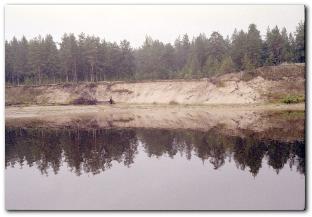
Drainage network
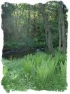
HYDROGRAPHIC NETWORK. Over 19500 rivers and 1800 lakes (Ladoga and Onega being the largest ones) form the H. N. of the Leningrad Oblast. The river network is dense and ramified. One exception is the Izhora Hills where the river network density is... more
|
|
|
|
hidden
|
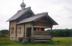
Holy Trinity Monastery of St. Aleksandr of Svir, the
The Holy Trinity Monastery of St. Alexander of Svir (the village of Staraya Sloboda/ Svirskoye, the Lodeynoye Pole district). The monastery was founded by Venerable Alexander Svirsky. In 1484 he settled in a forest area nearby the Svir River in... more
|
|
|
|
hidden
|
Industrial architecture
Industrial architecture. Study of structural and functional features of the production constructions in terms of their aesthetic expression started recently. On the material of the Leningrad region of such studies have not yet done. A small number... more
|
|
|
|
hidden
|
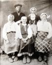
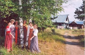
Karelians
Karelians (their own native name is kar'yalaizet) is an ethnic community. Among Karelians there are some ethnic local groups which can be stood out. The Karelian language is related to the Baltic-Finnic subgroup of the Finno-Ugric branch of the Ural... more
|
|
|
|
hidden
|
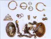
Kurgans (barrows) of the southern Ladoga Lake region.
Kurgans (barrows, burial mounds) of the southern Ladoga Lake region (the late 9th - early 13th centuries) pertain to so-called the Lake Ladoga region Chuds whose descendants took part in forming Vepses and Karels. They were likely to be "kolbyagi",... more
|
|
|
|
hidden
|
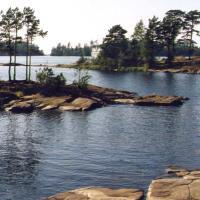
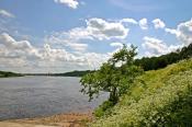
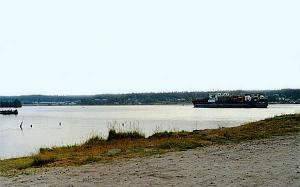
Ladoga Lake
LAKE LADOGA. Located in Leningrad Oblast and the Republic of Karelia. In the Middle Ages, it was called Nevo (Baltic Finnish nevo = “moss marsh.”) The current name originates from the middle Scand. Aldoga (fm the Baltic Finnish Alodejogi = “the... more
|
|
|
|
hidden
|
Ladoga Canals, the
LADOGA CANALS. They connect the mouth of the Volkhov River and the head of the Neva, extending along the south coast of Lake Ladoga. There are two canals, Staroladozhsky and Novoladozhsky. The canal construction was urged by the necessity to have a... more
|
|
|
|
hidden
|
Lodeynoye Pole District
LODEYNOYE POLE DISTRICT, a part of Leningrad Oblast located east of Lake Ladoga in the Svir River basin. In the north-west and north, it borders Olonets District of the Republic of Karelia; in the north-east and east, Podporozhye District; in the... more
|
|
|
|
hidden
|
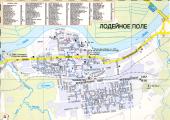
Lodeynoye Pole, town
LODEYNOYE POLE, town, adm. center of Lodeynoye Pole District. It is situated on the left bank of the Svir River. Population: 23,700. The Murmansk Highway extends across L. P., the town has a railway station on the Volkhovstroy-Petrozavodsk line... more
|
|
|
|
hidden
|
Nikolsky, urban settlement
NIKOLSKY, an urban settlement in the north-west of Podporozhye District. Population: 2,900. It is situated on a peninsula formed by a sharp bend of the Svir River. The name probably originates from the church of St. Nicholas the Miracle Worker... more
|
|
|
hidden
|
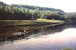
"Nizhnesvirsky", a reserve
The "Nizhnesvirsky" natural reserve is located on the territory of the Lodeynopolskiy District. Its are is 41615 hectares. It was founded on 11 June 1980 on the base of the Nizhnesvirsky reserve. It included the shore and the part of the water... more
|
|
|
|
hidden
|
Onega Lake
LAKE ONEGA (Onezhskoye Ozero), located in the north of Russia’s European part within the Republic of Karelia, Vologda Oblast (southern and south-eastern part) and Leningrad Oblast (south-western part.) The L. O. boast belongs to the north-eastern... more
|
|
|
|
hidden
|
Oyat River, the
OYAT, river, left-hand tributary of the Svir River. Length: 266 km. The average flow rate in the mouth is 54.8 cu. m/s, catchment area: 5220 sq. km. Its source is Lake Chaimozero on the Veps Hills (in Vologda Oblast, 7 km away from the Leningrad... more
|
|
|
|
hidden
|
Pasha River, the
PASHA, river, left-hand tributary of the Svir River. Length: 242 km. The average flow rate in the mouth is 69.2 cu. m/s, catchment area: 6650 sq. km. It flows out of Lake Pashozero in the east of Leningrad Oblast, and crosses Tikhvin and Volkhov... more
|
|
|
|
hidden
|
Podporozhye District
PODPOROZHYE DISTRICT, municipal entity. Population: 35,200. Area: 7705.5 sq. km. Located in the north-east of Leningrad Oblast. In the north-west and north, it borders Olonets, Pryazha, and Prionezhsky Districts of the Republic of Karelia; in the... more
|
|
|
|
hidden
|
Podporozhye District coat of arms and flag, the
The Podporozhye District's coat of arms and flag are approved officially with the decision of the Representative Assembly of the Municipal Union “Podporozhskiy rayon” (The Podporozhye District) of 21 April 2004, No. 152 and No. 153. The heraldic... more
|
|
|
|
hidden
|
Podporozhye, town
PODPOROZHYE, town, adm. center of Podporozhye District. It is situated 285 km (280 km by railway) north-east of St. Petersburg, on the Svir River. Population: 20,300. The town’s name is related to the rapids on the Svir. The Lodeynoye Pole-Vytegra... more
|
|
|
|
hidden
|
Svirstroy, urban settlement
SVIRSTROY, an urban settlement in Lodeynoye Pole District. Population: 1,000. It is situated on the left bank of the Svir River. S. has transport communications to Lodeynoye Pole and Podporozhye via the Svir and a motor road and railroad; 5 km... more
|
|
|
|
hidden
|
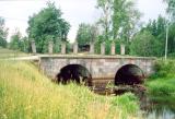
Syas Canals , the
SYAS CANALS. They connect the mouths of the Volkhov and Syas Rivers, and extend along the south-eastern coast of Lake Ladoga, being an extension of the Ladoga Canals. Currently they are in Volkhov District, from Nemyatovo village to Syasstroy town.... more
|
|
|
hidden
|
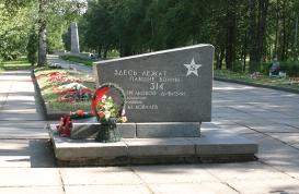
"The Victory at the Svir River", memorial, the
"The Victory at the Svir River" is a memorial in the town of Lodeinoye Pole. It was created according to the decision of the Karelian Front Council of War in memory of battles in the town area in 1941-1944. The memorial located on the high bank of... more
|
|
|
|
hidden
|
Vazhini, urban settlement
VAZHINI, an urban settlement in Podporozhye District. Population: 3,300. It is situated at the confluence of the Vazhinka and Svir rivers, north-east of Svir railway station on the Volkhovstroy-Murmansk line. The name originates from the Vazhinka... more
|
|
|
|
hidden
|
Verkhniye Mandrogi, village
VERKHNIYE MANDROGI, a village in Podporozhye District. Population: 403. The name’s origin is related to the Karelian words “mandere” = mainland, land, coast, or forest on a bedrock shore, and “jogi” = river. It is located on the right bank of the... more
|
|
|
|
hidden
|
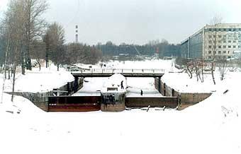
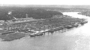
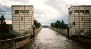
Verlhnesvirskaya hydroelectric power station
Verlhnesvirskaya hydroelectric power station is the part of the power hydro engineering complex on the river Svir. The Nizhnesvirskiy waterworks was built in the 1927 (urban village Svirstroy in the Lodeynoye Pole District). The hydroelectric power... more
|
|
|
|
hidden
|
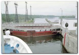
Volgo-Baltic Waterway, the
The VOLGO-BALTIC WATERWAY, artificial waterway in the North-West of Russia connecting the Neva River basin with the basins of rivers of the Volga and the Northern Dvina. Its history is traceable back to the Mariyinsky Canal System, the... more
|
|
|
|
hidden
|
Volkhov River, the
VOLKHOV, river. It flows out of Lake Ilmen in Novgorod Oblast, extends across Kirishi and Volkhov Districts of Leningrad Oblast, and it flows into the Volkhov Bay of Lake Ladoga. Length: 224 km, of which 112 km within Leningrad Oblast. The river bed... more
|
|
|
|
hidden
|
Voznesenye, urban settlement
VOZNESENYE, an urban settlement in Podporozhye District. Population: 2,800. It is situated at the head of the Svir River flowing out of Lake Onega. It is connected to Podporozhye town with a motor road and via the Svir. North-east of V., towards... more
|
|
|
|
hidden
|
White Sea-Baltic Sea Waterway, the
WHITE SEA-BALTIC SEA WATERWAY, a canal system connecting the White Sea and the Baltic Sea. It includes the White Sea-Baltic Canal, Lake Onega, Svir River, Ladoga Canals, and Neva River. It has access to the Volga-Baltic Waterway via Lake Onega. The... more
|
|
|
|
hidden
|
|
hidden
|
|
hidden
|
|
hidden
|
|
hidden
|