Articles
/
Maps and plans
Maps and plans
Subject /
Topography
Subject /
Ethnic culture//
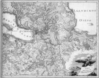
MAPS AND PLANS. The oldest M.a .P. of the Leningrad Oblast area are dated 16th century. The Neva Land and the Karelian Isthmus with the towns of Noteborg (Schlusselburg) and Kexholm (Priozersk), although with many distortions, are presented in “Carta Marina” by O. Magnus (also known as “Carta Gothica”, 1539; engraved in Venice.) The appearance of M.a.P. was promoted by wars (this is how e.g. the 1610 plans of Kexholm siege were drawn), and the Russian-Swedish border demarcation. In A. Bureus’s map “Orbis Arctoi” (1626) the outlines of Lakes Ladoga, Onega, and Ilmen were correctly presented for the first time. In the 17th century, M.a.P. of Ingermanlandia were made during the land surveys by Swedish authorities (e.g. General Map of Ingermanlandia 1704.) The first Russian map of the region, “Geographical Drawing of Izhora Land”, was made by A. Schonebeck in 1704-05. On its basis, and with regard to the changes after the construction of St. Petersburg, a map of Ingermanlandia was drawn for “The Russian Atlas” under the leadership of I. K. Kirilov in 1727 (published in Latin in Nuremberg in 1734.) The eastern parts of the current Leningrad Oblast were also mapped in the 18th century, in particular due to their economic development. M.a.P. of Ladoga’s south coast appeared in the 1720-40s after the Ladoga Canal was opened (see Ladoga Canals.) In 1762, a map of Obonezhskaya Pyatina of Novgorod Gubernia was drawn, where the timber was suitable for shipbuilding. In 1821, the General Map of Novgorod Gubernia was published. M.a.P. of Vyborg, St. Petersburg, and Novgorod Gubernias were made in the course of the General Land Survey in the 2nd half of the 18th century. In the 18th-19th cc., ordnance survey maps were made in the oblast territory, involving military land surveyors and topographers P. I. Neuhardt, F. F. Schubert, and A. R. Bonsdorf. Among the results of their effort was e.g. The Military Topography Map of St. Petersburg Gubernia (1863). In 1849, the Ethnographic Map (ed. P. I. Koeppen), and in 1852, “The Geological Map of St. Petersburg Gubernia” (ed. S. S. Kutorga) were published. The entire area of the current Leningrad Oblast is presented in the “Ethnographic Map of European Russia” (ed. P. I. Koeppen, 1851.) The mapping continued in the Soviet period. In 1927, a new ethnographic map was published, covering the entire Leningrad Oblast, as an attachment to D. A. Zolotarev’s book “Ethnic Structure of the Population of the North-Western Region and Karelian ASSR.” However, publishing of detailed and exact M.a.P. for public access was prevented by the secrecy regulations. In 1934, “The Atlas of Leningrad Oblast and Karelian ASSR” was published, and in 1967, “The Atlas of Leningrad Oblast” containing, apart from the population and economic development maps, also a map of cultural institutions. Since the late 1980s, many maps and atlases have been published, intended for tourists, fishermen, mushroomers, and orienteering fans. Among them are the atlases “Leningrad Oblast and District Centers” (scale 1:200000), “South-East of Leningrad Oblast” (1:100000), “Karelian Isthmus” (1:100000), “Rivers and Lakes of the Karelian Isthmus” (1:50000). The plans of particular towns of Leningrad Oblast are published. Published in 2005 was “The Large Motor Road Atlas of St. Petersburg and Leningrad Oblast”, where the western and central parts of the oblast are represented by 1:100000 scale maps, and the less populated eastern part, by 1:200000 maps. Apart from the roads, the monuments are too indicated in the maps. A two-volume “Archeological Map of Leningrad Oblast” was published (ed. V. A. Lapshin; 1990, 1995) where the materials are grouped by the district. Health and environmental mapping has been done, see “Environmental Map of Leningrad Oblast” (2005). In 2006, Discus Media published The Large Motor Road and Reference Atlas of Leningrad Oblast, picturing the current state of the region in the best way. M.a.P. of some parts of the oblast are appended to many today’s publications of regional studies. M.a.P. of the Leningrad Oblast area are kept in the collections of various libraries and archives in and outside Russia (mainly in Sweden), in particular in the collection of the Leningrad Oblast State Archive in Vyborg: F. 531 “Maps, Plans, and Drawings of Vyborg Town and Vyborg, Kuopio, and Mikkeli Gubernias” (854 files, 1751–1944); F. 532 “Maps, Plans, and Drawings of railway, highway, and waterway communications of Vyborg and Vyborg Gubernia” (57 files, 1812–1938.)
Authors
Chistyakov, Anton Yuryevich
Persons
Bonsdorf, Aksel Robertovich (Aksel Edward)
Bureus, Andreas
Keppen, Pyotr Ivanovich
Kirilov, Ivan Kirillovich
Kutorga, Stepan Semyonovich
Lapshin, Vladimir Anatolyevich
Magnus, Olaus
Neigardt, Pavel Ivanovich
Schubert, Fyodor Fyodorovich
Shkhnonebek, Adrian
Zolotarev, David Alekseyevich
Geography
Topographical landmarks/Ilmen Lake
Historical Toponyms/Ingermanlandia (Ingria)
Topographical landmarks/Karelian Isthmus, the
Historical Toponyms/Kuopio Gubernia (Province)
Topographical landmarks/Ladoga Canal, the
Topographical landmarks/Ladoga Lake
Historical Toponyms/Mikkeli Gubernia (Province)
Historical Toponyms/Novgorod Gubernia (Province)
Historical Toponyms/Novgorod Gubernia (Province)/Obonezhskaya Pyatina ("Fifth")
Topographical landmarks/Onega Lake
Topographical landmarks/Priladozhye
Topographical landmarks/Prinevye
Leningrad Oblast, the/Priozersk District/Priozersk Town
Historical Toponyms/Saint Petersburg Gubernia, the
Leningrad Oblast, the/Shlisselburg Town
Historical Toponyms/Grand Principality of Finland/Vyborg Province
Leningrad Oblast, the/Vyborg District/Vyborg Town
Bibliography
Санкт-Петербург и Ингерманландия в архивах Швеции. Швеция в архивах Санкт-Петербурга. Материалы российско-шведского семинара. СПб., 2005
Эренсверд У. Шведское картографирование Ингерманландии // Шведы на берегах Невы. Стокгольм, 1998
Maps of the Neva river and adjacent areals in Swedish archives / Ed. by L. Bagrov & H. Kohlin. Malmo, 1953.
ОКРЕСТНОСТИ ПЕТЕРБУРГА. География, история, описания достопримечательных мест и событий. URL: http://around.spb.ru
Subject Index
The Leningrad Oblast State Archive in Vyborg
|