Articles
/
Oyat River, the
Oyat River, the
Subject /
Topography/Reservoirs and waterways
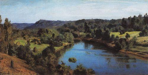
OYAT, river, left-hand tributary of the Svir River. Length: 266 km. The average flow rate in the mouth is 54.8 cu. m/s, catchment area: 5220 sq. km. Its source is Lake Chaimozero on the Veps Hills (in Vologda Oblast, 7 km away from the Leningrad Oblast border.) In Leningrad Oblast, O. flows within Podporozhye and Lodeynoye Pole Districts. Initially it flows to the west, after Shondovichi village it turns to the north, changes the direction again to southwest before Vinnitsi village, to north-west before Alyokhovschina, and in way of Nikonovschina village it makes a turn and after that, retaining the westward direction in general, forms numerous bends and flows into the Svir downstream of Domozhirovo village. The most important tributaries are Lower Kurba, Sondala, Tuksha, Shoksha, Kuzra, Tyanuksa, Shapsha, Ascina, Savinka, Viliga, Tiksha, Bolshaya Lubloga, Chegla. The river’s name is related to the Baltic Finnish “oja” = brook. In the middle and lower reach of O. there are several dozens of burial mounds of the Ladoga Coast culture of the late 1st and early 2nd millennium A.D. In the basin of O. there are the localities of Vinnitsi and Tervenichi known from the 12th century, and Ladva, Ozera, and Yaroslavichi known by the data of scribe rolls of the late 15th century. These and some other localities in the upper reach of the river are inhabited by the Oyat group of the Vepses. In the middle reach of O. there is Imochenitsi, an country estate where artist V. D. Polenov lived. The landscape of the river valley is diversified and picturesque. The basin of its upper reach is included in the “Veps Forest” natutal reserve .
Authors
Yegorov, Sergey Borisovich
Persons
Polenov, Vasily Dmitriyevich
Geography
Leningrad Oblast, the/Lodeynoye Pole District/Alyokhovshchina Village
Topographical landmarks/Ashchina River, the
Topographical landmarks/Bolshaya Lubloga River, the
Topographical landmarks/Chaymozero
Topographical landmarks/Chegla River, the
Leningrad Oblast, the/Lodeynoye Pole District/Domozhirovo Village
Topographical landmarks/Kuzra River, the
Leningrad Oblast, the/Podporozhye District/Ladva Village
Leningrad Oblast, the/Lodeynoye Pole District
Leningrad Oblast, the/Lodeynoye Pole District/Nikonovshchina Village
Topographical landmarks/Nizhnyaa Kurba River, the
Leningrad Oblast, the/Podporozhye District/Ozera Village
Leningrad Oblast, the/Podporozhye District
Topographical landmarks/Savinka River, the
Topographical landmarks/Shapsha River, the
Topographical landmarks/Shoksha River, the
Leningrad Oblast, the/Podporozhye District/Shondovichi Village
Topographical landmarks/Sondala River, the
Topographical landmarks/Svir River, the
Leningrad Oblast, the/Lodeynoye Pole District/Tervenichi Village
Topographical landmarks/Tiksha River, the
Topographical landmarks/Tuksha River, the
Topographical landmarks/Tyanuksa River, the
Topographical landmarks/Veps Hills, the
Topographical landmarks/Viliga River, the
Leningrad Oblast, the/Podporozhye District/Vinnitsi Village
Neighbouring Territories/Vologda Oblast, the
Leningrad Oblast, the/Podporozhye District/Yaroslavichi Village
Bibliography
«Вепсский лес». Природный парк. Путеводитель. Б.г., б.и.
Егоров С.Б. Этнокультурное развитие и хозяйство приоятских вепсов во второй половине XX¬ – начале XXI века // Этнографическое изучение Северо-Запада России: Итоги полевых исследований 2003 г. Материалы VIII Региональной научной конференции молодых ученых / Под ред. В.А. Козьмина. СПб., 2003., С.7-17
Ильина Л.Л., Грахов А.Н. Бесценное богатство: Рассказ о реках и озерах Ленинградской области. Л., 1978, С.68
Subject Index
Imochenitsi, a country estate
Kurgans (barrows) of the southern Ladoga Lake region.
Veps
"Vepssky Les" ("Veps Forest"), a park
|