Articles
/
"Vepssky Les" ("Veps Forest"), a park
"Vepssky Les" ("Veps Forest"), a park
Subject /
Nature memorials
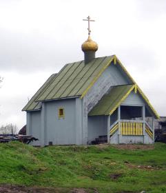
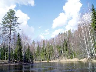
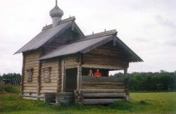
Vepssky Les ("Veps Forest") is a state natural park. It is located in the territory of the Podporozhie, Tihvin, Boksitogorsk, Lodetnoy Pole districts. It occupies the area of 189,1 thousand hectares. It was founded with resolution of the Governor of the Leningrad Oblast of 14 September 1999, No. 302-pg, of 25 January 2001, No. 16-pg and of 14tMay 2003, No. 81-pg. It is governed with the Government of the Leningrad Oblast. The purpose of the foundation is the saving of the particularly precious natural complexes and objects which are not affected by economical activity: typical for the middle taiga of the North-West Russia landscape terrain features; oldage indigenous fir groves, oldage forests of others kinds; upland sphagnous bogs of the west-russian type; oligotrophic and oligotrophic lakes; rare species of the flora and fauna; unique landscapes; restoring of the breaking ecosystems (reafforestation, salvaging of the sunk wood, restoring of the spawning ground of the precious fish’s races and so on); the saving of the drained basin forestry ecosystems on the watershed of the rivers of the Baltic and the Caspian; the saving of the large woodlands for improvement surface air stratums of the region; the including of the territorial nature park to the structure of “ekologicheskogo karkasa” (The Ecological Frame of the Leningrad Oblast along with the others nature conservation territories and the recreational zones. Besides nature conservation purposes the park performs scientific and historical functions: the saving, research and usage in the scientific, touristic and recreational purpose the high natural and culture-historical potential of the territory; the stimulation of the revival of the veps language and culture; the foundation of the region ethnographical centre for research of the veps culture and Russian Mezhozerie; the organization of the architectural and ethnographical expositions on the basis of historic groups of the populated places, relics of the architecture and mode of life, folklore and ritual traditional that are kept on their territory.
Authors
Tripolskaya, Anna Aleksandrovna
Geography
Leningrad Oblast, the/Boksitogorsk District
Leningrad Oblast, the/Lodeynoye Pole District
Leningrad Oblast, the/Podporozhye District
Leningrad Oblast, the/Tikhvin District
Bibliography
ООПТ РАДИ ЖИЗНИ НА ЗЕМЛЕ. URL: http://pa.iucn.ru/
Новости. URL: http://www.lenobl.ru
Mentioned in articles:
|
hidden
|
Boksitogorsk District
BOKSITOGORSK DISTRICT, a part of Leningrad Oblast. Population: 34,800. Area: 7163 sq. km. Adm. center: Boksitogorsk Town. The district comprises Yefimovsky urban settlement and 275 inhabited localities. It borders Tikhvin District of Leningrad... more
|
|
|
|
hidden
|
Especially restricted natural areas
The especially restricted natural areas. These areas of land, water surface and airspace which have the natural complexes and objects. These areas have special environmental, scientific, cultural, aesthetic, recreational and curative value. These... more
|
|
|
hidden
|
Kurba, settlement
KURBA, a settlement in Podporozhye District. Population: 368. Located in the upper reaches of the Oyat River. The name originates from the Kurba River, a left-hand tributary of the Oyat. It was founded in 1959 as a settlement for timber harvesters.... more
|
|
|
|
hidden
|
Ladva, group of villages
LADVA, a group of Veps villages in the south-eastern part of Podporozhye District. Located on the banks of the Oyat River and Lake Ladvinskoye. It consists of the villages of Vasilievskaya, Kazychenskaya, Makarievskaya, Minitskaya, Fyodorovskaya,... more
|
|
|
|
hidden
|
Obonezhye
OBONEZHYE, historic and cultural region in the north-west of the European Russia. It included lands around Lake Onega. A part of the state of Novgorod: written sources from the 12th century mention the Obonezhskaya Hundred as an adm. and territorial... more
|
|
|
|
hidden
|
Oyat River, the
OYAT, river, left-hand tributary of the Svir River. Length: 266 km. The average flow rate in the mouth is 54.8 cu. m/s, catchment area: 5220 sq. km. Its source is Lake Chaimozero on the Veps Hills (in Vologda Oblast, 7 km away from the Leningrad... more
|
|
|
|
hidden
|
Ozyera, group of Veps villages
OZYERA, a group of Veps villages in Podporozhye District. Located on the banks of the Oyat River and Lake Oyat. Equivalent Veps name: Jarved. Includes the villages of Kuzminskaya, Lukinskaya, Martemianovskaya, Ozhegovskaya (Krysanova Gora.)... more
|
|
|
|
hidden
|
Parks
Park is a specially plan area with artificially planted trees and with the paths, trails, ponds. The first parks on the territory of the Leningrad Oblast were founded in the 18th century. They were part of imperial residences, grand prince... more
|
|
|
|
hidden
|
Pasha River, the
PASHA, river, left-hand tributary of the Svir River. Length: 242 km. The average flow rate in the mouth is 69.2 cu. m/s, catchment area: 6650 sq. km. It flows out of Lake Pashozero in the east of Leningrad Oblast, and crosses Tikhvin and Volkhov... more
|
|
|
|
hidden
|
Podporozhye District
PODPOROZHYE DISTRICT, municipal entity. Population: 35,200. Area: 7705.5 sq. km. Located in the north-east of Leningrad Oblast. In the north-west and north, it borders Olonets, Pryazha, and Prionezhsky Districts of the Republic of Karelia; in the... more
|
|
|
|