Articles
/
Tikhvin Canal System
Tikhvin Canal System
Subject /
Topography/Reservoirs and waterways
TIKHVIN CANAL SYSTEM, a traffic artery in the north-west of European Russia. It connected the basins of the Baltic Sea and the Volga in the 19th-20th cc. It began at the city of Rybinsk on the Volga (later at the Rybinsk Reservoir), extended via the Mologa, Chadogoscha, Goryun, Sominka, and Valchina rivers, Tikhvin Canal, further via the Tikhvinka and Syas Rivers, Ladoga Canal, the Neva, and ended in St. Petersburg. Its total length was 924 km. Surveys for construction of a waterway intended to ensure cargo circulation between St. Petersburg and the Volga Land were conducted in the early 18th c., but the construction was only completed in the early 19th c. In 1811, T. C. S. was put into operation, but its reconstruction was continued. It was mainly used for cargo shipping, and to a lesser extent, for passenger service. The route of T. C. S. within the current Leningrad Oblast extended via Boksitogorsk, Tikhvin, Volkhov, and Kirovsk Regions. The most important stations were Novaya Ladoga, Kolchanovo, Syasskiye Ryadki, Tikhvin, and Somino. The construction of the Mariyinskaya Canal System and railroads resulted in the loss of importance of T. C. S.; it was officially closed in 1956, although local service continued until 1965. Currently, in Tikhvin and Boksitogorsk Districts there are remainders of the waterworks (locks and dams) that are historic/cultural monuments. At the place of watershed (6 km north of Yefimovsky urban settlement) a monument to Peter I who visited these places between 1712 and 1716 was installed in 1862.
Authors
Yegorov, Sergey Borisovich
Geography
Leningrad Oblast, the/Boksitogorsk District
Topographical landmarks/Chagodoshcha River, the
Topographical landmarks/Goyun River, the
Leningrad Oblast, the/Kirovsk District
Leningrad Oblast, the/Volkhov District/Kolchanovo Village
Topographical landmarks/Ladoga Canal, the
Topographical landmarks/Mariyinskaya Canal System
Topographical landmarks/Mologa River, the
Topographical landmarks/Neva River, the
Leningrad Oblast, the/Volkhov District/Novaya Ladoga Town
Topographical landmarks/Sominka River, the
Leningrad Oblast, the/Boksitogorsk District/Somino Village
Topographical landmarks/Syas River, the
Historical Toponyms/Syas'skiye Ryadki, settlement
Leningrad Oblast, the/Tikhvin District
Leningrad Oblast, the/Tikhvin District/Tikhvin Town
Topographical landmarks/Tikhvinka River, the
Topographical landmarks/Tikhvinsky Canal, the
Topographical landmarks/Valchina River, the
Leningrad Oblast, the/Volkhov District
Leningrad Oblast, the/Boksitogorsk District/Yefimovsky Urban Settlement
Bibliography
Бучацкий Л.Х. Тихвинская система. технические и экономические данные и материалы для проекта улучшения водного пути. СПб., 1893
Виноградова Л.В. Когда сияли купола. Тихвин, 1997
Ильина Л.Л., Грахов А.Н. Бесценное богатство: Рассказ о реках и озерах Ленинградской области. Л., 1978, С.66
Калинин М.А., Федяев А.И. Бокситогорск – Пикалево. Л.. 1983., С.56-58
Medline.ru - ТИХВИНСКАЯ ВОДНАЯ СИСТЕМА - ИСТОРИЯ И СОВРЕМЕННОЕ СОСТОЯНИЕ. URL: http://www.medline.ru, http://www.medline.ru/public/art/tom3/art2.phtml
Mentioned in articles:
|
hidden
|
Boksitogorsk District
BOKSITOGORSK DISTRICT, a part of Leningrad Oblast. Population: 34,800. Area: 7163 sq. km. Adm. center: Boksitogorsk Town. The district comprises Yefimovsky urban settlement and 275 inhabited localities. It borders Tikhvin District of Leningrad... more
|
|
|
|
hidden
|
Drainage network
HYDROGRAPHIC NETWORK. Over 19500 rivers and 1800 lakes (Ladoga and Onega being the largest ones) form the H. N. of the Leningrad Oblast. The river network is dense and ramified. One exception is the Izhora Hills where the river network density is... more
|
|
|
|
hidden
|
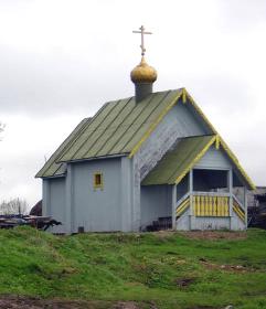
Somino, Village
SOMINO, a village in Boksitogorsk District. Population: 383. According to a legend, the name originates from the Sominka River where Peter I caught “som”, a catfish. More probable is the toponym’s origin in the Baltic Finnish “so” = marsh, knowing... more
|
|
|
|
hidden
|
Tikhvin District
TIKHVIN DISTRICT, municipal entity. Population: 14,600. Area: 6997.5 sq. km. Adm. center: Tikhvin Town. The district comprises 198 rural localities united into 8 rural settlements. It is located in the east and south-east of Leningrad Oblast. It... more
|
|
|
|
hidden
|
Tikhvin, town
TIKHVIN, town, adm. center of Tikhvin District. It is situated on the Tikhvinka River. Population: 63,300. Close to T. is the Novaya Ladoga-Yaroslavl highway. Within the town lines there is Tikhvin railway station on the St. Petersburg-Vologda... more
|
|
|
|
hidden
|
Tikhvinka River, the
TIKHVINKA, river, right-hand tributary of the Syas River. Length: 155 km. Average flow rate: 19.9 cu. m3/s. It originates from Lake Krupino in Boksitogorsk District, 5 km north of Yefimovsky urban settlement, and flows in the latitudinal direction... more
|
|
|
|
hidden
|
Yefimovsky, urban settlement
YEFIMOVSKY, an urban settlement in Boksitogorsk District. Population: 3,900. It is situated on the Valchenka, Bystraya, and Sominka rivers. In the early 20th c. it was a railway station settlement at the St. Petersburg-Vologda railroad. It got... more
|
|
|
|