Articles
/
Trade route from the Varangians to the Greeks
Trade route from the Varangians to the Greeks
Subject /
Relics
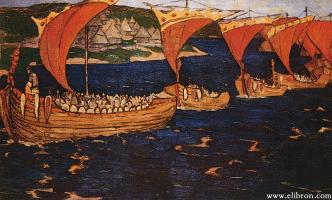
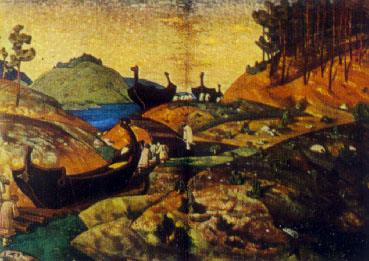
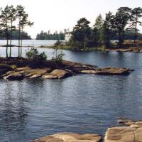
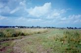
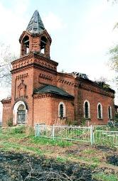
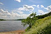
The trade route from "the Varangians to the Greeks". During the 9th-11th centuries it connected Rus and the Northern Europe with Byzantine Empire on the route: the Baltic Sea - the Neva River - Ladoga Lake - the Volkhov River - Ilmen Lake - the Lovat River - portages to the Western Dvina River - portages to the Dnieper River and then with the Dnieper River stream to the Black Sea. The military-trade route connected the old Russian towns (Ladoga, Novgorod, Smolensk, Kiev) with Constantinople and the European trading centres (Dorestadt, Hedeby, Birka and others). "Tale of Bygone Years" (Russian Primary Chronicles) (the early 12th century) describes the route in connection with an apocryphal legend about the Apostle Andrew travel from the Black Sea region to "the Kievan Mountains" and the place of "Future" Novgorod and then further to Rome. Voyages of the Russians of the middle of the 10th century were described by Constantine VII Porphyrogennetos. On our days sail-rowing boats of the scientific expedition "Nevo" (between 1985-1995) went 2720 km from Bolshoy Tyuters Island in the Gulf of Finland as far as Berezan Island in the Dnieper-Bug estuary during 90-95 one-day passages (in all with day-spendings - 110-115 days). The getting through portages such as the Lopat River - the Dvina River and the Dvina River - the Dnieper River took about two weeks. Along the route there were 110 old Russian base stations (320 archarlogical monuments): towns, opened trade and crafts settlements, sentry fortresses, navigation references, rural settlements. Through contacts between the Baltic and Black Sea were traced from 825 - 839. From the 11th century the route southern part was attacked by nomads at the Dnieper rapids. On the Leningrad Oblast territory there are the archaelogical corroborations of the routing and working of the route "from the Varangians to the Greeks": at B. Tyuters Island harbour in the Gulf of Finland; in Peterhof and the Galley Harbour at the Neva River mouth; on the Volkhov River, around the harbour of the town settlement in Staraya Ladoga (from the middle of the 8th century); in areas of rapids at the villages of Noviye (New) Duboviki, Velsi - gostinopolye, Gorodishche-Podsopye.
Authors
Plotkin, Konstantin Moiseyevich
Persons
Konstantin VII Porhyrogenitus
Geography
Topographical landmarks/Baltic Sea, the
Topographical landmarks/Bolshoy Tyuters Island
Leningrad Oblast, the/Volkhov District/Gostinopolye Village
Topographical landmarks/Ilmen Lake
Topographical landmarks/Ladoga Lake
Historical Toponyms/Ladoga Town
Topographical landmarks/Lovat River, the
Topographical landmarks/Neva River, the
Historical Toponyms/Noviye Duboviki
Saint-Petersburg City/Peterhof Town
Leningrad Oblast, the/Kirishi District/Podsopye Village
Leningrad Oblast, the/Volkhov District/Staraya Ladoga Village
Topographical landmarks/Volkhov River, the
Topographical landmarks/Zapadnaya Dvina River, the
Bibliography
Лебедев Г. С., Жвиташвили Ю. Б. Дракон «Нево» на Пути из Варяг в Греки: Археол.-навигац. исследование древних водных коммуникаций между Балтикой и Средиземноморьем. СПб., 1999.
Повести Древней Руси / Пер. и ред. Д.С. Лихачева. Л., 1980, С.126
Константин Багрянородный. Об управлении империей. Текст, перевод, комментарии / Под ред. Г.Г. Литаврина, А.П. Новосильцева. М., 1989, С.44-51, 291-332
Subject Index
"Nevo", archeology - navigation expedition
Mentioned in articles:
|
hidden
|
Gulf of Finland, the
GULF OF FINLAND, in the eastern part of the Baltic Sea. Area: about 29,800 sq. km (7% of the Baltic Sea area.) Length: 400 km (from the Khanko Peninsula to SPb.) Max. width: 130 km (near the western border of Leningrad Oblast, at the meridian of... more
|
|
|
|
hidden
|
Kirishi District
KIRISHI DISTRICT, a part of Leningrad Oblast. Area: 3009 sq. km. Population: 67,700. In the west, it borders Tosno, in the north-west, Kirovsk, in the north, Volkhov, and in the east, Tikhvin Districts of Leningrad Oblast; in the south-east, with... more
|
|
|
|
hidden
|
Kirishi District coat of arms, the
The Kirishi District's coat of arms was approved with the decision of the municipality of the Municipal Union “Kirishsky rayon” (The Kirishi District) of 30 January 1997, No. 2/13. The heraldic description of the coat of arms: “Within the azure... more
|
|
|
|
hidden
|
Kirovsk District coat of arms and flag, the
The Kirovsk District's coat of arms and flag were official approved with the decisions of the Municipal Assembly of the Municipal Union “Kirovskiy rayon” (The Kirovsk District) of 15 April 1998, No. 224 and 20 January 1999. The heraldic description... more
|
|
|
|
hidden
|
Ladoga Lake
LAKE LADOGA. Located in Leningrad Oblast and the Republic of Karelia. In the Middle Ages, it was called Nevo (Baltic Finnish nevo = “moss marsh.”) The current name originates from the middle Scand. Aldoga (fm the Baltic Finnish Alodejogi = “the... more
|
|
|
|
hidden
|
Lebedev, Gleb Sergeyevich (1943-2003), a scientist
Lebedev, Gleb Sergeyevich (1943-2003, Staraya Ladoga Village), an archaeologist, a professor of the Leningrad/St. Petersburg University (1990). He graduated from the history faculty of the Leningrad State University in 1968, taught at the... more
|
|
|
|
hidden
|
Roads
ROADS. Historically, the road network in the territory of Leningrad oblast has been developing unevenly: the regions east of the Volkhov River are worse provided with R. because the principal economic, military, and cultural centers have always been... more
|
|
|
|
hidden
|
Staraya Ladoga, Village
STARAYA LADOGA (Ladoga before 1704), a village in Volkhov District. Population: 2200. Located on the left bank of the Volkhov River where the Ladozhka (Yelena) River flows into it. The toponym is of a Baltic Finnish origin, from Alodejogi (lower... more
|
|
|
|
hidden
|
Volkhov District
VOLKHOV DISTRICT, a part of Leningrad Oblast. Area: 5124 sq. km, population: 97,300. Established in 1927. Adm. center: Volkhov Town. V. D. comprises the towns of Syasstroy and Novaya Ladoga, and 277 rural localities. Located south of Lake Ladoga on... more
|
|
|
|
hidden
|
Volkhov River, the
VOLKHOV, river. It flows out of Lake Ilmen in Novgorod Oblast, extends across Kirishi and Volkhov Districts of Leningrad Oblast, and it flows into the Volkhov Bay of Lake Ladoga. Length: 224 km, of which 112 km within Leningrad Oblast. The river bed... more
|
|
|
|
hidden
|
Vsevolozhsk District
VSEVOLOZHSK DISTRICT, a part of Leningrad Oblast. Area: 2945.4 sq. km. Population: 215,200. Adm. center: Vsevolozhsk Town. Comprises Sertolovo Town, six urban settlements (Dubrovka, settlement named after Morozov, settlement named after Sverdlov,... more
|
|
|
|