|
hidden
|
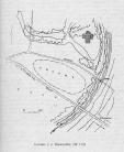
Ancient settlements (selishche)
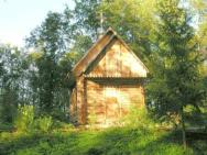
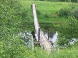
Selishches, remains of unfortified settlements, discovering according to the presence of the culture lay and withdrawn material. The search of ancient settlements is embarrassed for lack of external indications. More then 120 ancient settlements... more
|
|
|
|
hidden
|
Cherepovets Gubernia, the
CHEREPOVETS GUBERNIA, adm. and territorial unit with the center in the city of Cherepovets in the North-West of Russia in the early 20th century. The resolution to establish C. G. was adopted in 1918 at the meeting of representatives of five... more
|
|
|
hidden
|
Children Art Schools
CHILDREN’S ARTS SCHOOLS (CAS). In the last years Children’s Musical Schools (CMS) and Children’s Painting Schools (CPS) have had a growing tendency for unification into Children’s Arts Schools (CAS). By 2007 the Leningrad oblast had had 104 CAS,... more
|
|
|
|
hidden
|
Culture of Mounds
The Culture of Mounds. Mounds are high steep-side hills with the flat top and with the circle made of boulders at the foot. The area of the mound culture include basins of Ilmen Lake, the Msta, Volkhov, Luga rivers. There are mounds in the Luga,... more
|
|
|
|
hidden
|
Drainage network
HYDROGRAPHIC NETWORK. Over 19500 rivers and 1800 lakes (Ladoga and Onega being the largest ones) form the H. N. of the Leningrad Oblast. The river network is dense and ramified. One exception is the Izhora Hills where the river network density is... more
|
|
|
|
hidden
|
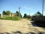
Dubno, village
DUBNO, a village in Volkhov District. Population: 38. It is located 18 km away from Novaya Ladoga town, to which D. is subordinated administratively. It is located on the Staroladozhsky and Novoladozhsky Canals at the southern coast of Lake Ladoga.... more
|
|
|
|
hidden
|
Eparhy of Novgorod
Eparhy of Novgorod. It is one of the oldest eparchies in Russia (it has been being since 992). The eparchy was the largest, it included five administrative regions (pyatinas) as well as the Pskov, Onega Lake, Karelia lands and the region of the... more
|
|
|
|
hidden
|
Issad, village
ISSAD (Izsad in the 19th c.), a village in Volkhov District. Population: 1100. It is located on the right bank of the Volkhov River. The Murmansk Highway extends close to I. The name originates from the Old Russian “issad”/”isad” = trade wharf. In... more
|
|
|
|
hidden
|
Kirovsk District
KIROVSK DISTRICT, a part of Leningrad Oblast. Area: 2590.9 sq. km. Population: 97,000. Located in the central part of Leningrad Oblast. In the north, it borders the Lake Ladoga coast; in the north-west and west, Vsevolozhsk District, in the west,... more
|
|
|
|
hidden
|
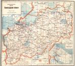
Leningrad Oblast, the
LENINGRAD OBLAST, subject territory of RF. Area: 83,900 sq. Km (max. Extension from west to east: 446 km, north to south: 325 km.) Population (as of 2002): 1,669,000. The Oblast borders Pskov and Novgorod Oblasts in the south, Vologda Oblast in the... more
|
|
|
|
hidden
|
Lodeynoye Pole District
LODEYNOYE POLE DISTRICT, a part of Leningrad Oblast located east of Lake Ladoga in the Svir River basin. In the north-west and north, it borders Olonets District of the Republic of Karelia; in the north-east and east, Podporozhye District; in the... more
|
|
|
|
hidden
|
Meleksa, village
MELEKSA, a village in Volkhov District. Population: 24. Located on the right bank of the Syas River. The name is of a Baltic Finnish origin. There is no information as to the date of its emergence. In the late 19th and early 20th century, carpenters... more
|
|
|
|
hidden
|
Municipal Unions
MUNICIPAL ENTITIES, urban or rural (may comprise several united rural localities, such as a volost in Leningrad Oblast) – a settlement, municipal district, or urban area (and an intra-city area of a federal level city), where local government is... more
|
|
|
hidden
|
Natural monuments
The natural monument is the category of the specially protected natural areas and in the international classification they have status of the natural monument. They are a small area, which include important natural objects (terrain feature, groves... more
|
|
|
|
hidden
|
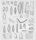
Neolithic monuments, The
The Neolithic monuments. The Neolithic (New Stone Age, 8000 - 3000 BC) is the epoch of farming and cattling appearance, spinning and weaving, new techniques of processing of stones and ceramics. In the Eastern Europe forest zone the Neolithics is... more
|
|
|
|
hidden
|
Novaya Ladoga, town
NOVAYA LADOGA, town in Volkhov District. Population: 10,000. Located in the central part of Leningrad Oblast in the Priladozhskaya Lowland, in the mouth of the Volkhov River, 25 km north of Volkhov Town. Administratively, the town also comprises... more
|
|
|
|
hidden
|
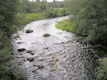
Pasha River, the
PASHA, river, left-hand tributary of the Svir River. Length: 242 km. The average flow rate in the mouth is 69.2 cu. m/s, catchment area: 6650 sq. km. It flows out of Lake Pashozero in the east of Leningrad Oblast, and crosses Tikhvin and Volkhov... more
|
|
|
|
hidden
|
Pasha, village
PASHA, a village in Volkhov District. Population: 3805. Before the 1980s, it was called Pashsky Perevoz [Pasha Ferry] after the ferry crossing over the Pasha River. It is connected to the neighboring localities and the district center by a highway... more
|
|
|
hidden
|
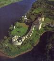
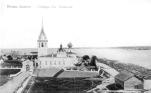
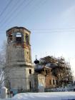
Staraya Ladoga, Village
STARAYA LADOGA (Ladoga before 1704), a village in Volkhov District. Population: 2200. Located on the left bank of the Volkhov River where the Ladozhka (Yelena) River flows into it. The toponym is of a Baltic Finnish origin, from Alodejogi (lower... more
|
|
|
|
hidden
|
Syasstroy, town
SYASSTROY, a town in Volkhov District. Population: 13,700. It situated in the lower reach of the Syas River, where the Valgomka flows into it. The etymology of the name is typical for settlements attached to industrial facilities erected in the... more
|
|
|
|
hidden
|
Tikhvin Canal System
TIKHVIN CANAL SYSTEM, a traffic artery in the north-west of European Russia. It connected the basins of the Baltic Sea and the Volga in the 19th-20th cc. It began at the city of Rybinsk on the Volga (later at the Rybinsk Reservoir), extended via the... more
|
|
|
|
hidden
|
Tikhvin District
TIKHVIN DISTRICT, municipal entity. Population: 14,600. Area: 6997.5 sq. km. Adm. center: Tikhvin Town. The district comprises 198 rural localities united into 8 rural settlements. It is located in the east and south-east of Leningrad Oblast. It... more
|
|
|
|
hidden
|
Volkhov District coat of arms and flag, the
The Volkhov District's coat of arms and flag are the official approved symbols of the Municipal Union “Volhovskiy rayon” (the Volkhov District) (the coat of arms was approved with the decision of the Representative Assembly of the Municipal Union... more
|
|
|
|
hidden
|
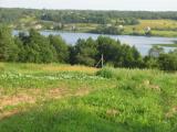
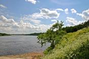
Volkhov River, the
VOLKHOV, river. It flows out of Lake Ilmen in Novgorod Oblast, extends across Kirishi and Volkhov Districts of Leningrad Oblast, and it flows into the Volkhov Bay of Lake Ladoga. Length: 224 km, of which 112 km within Leningrad Oblast. The river bed... more
|
|
|
|
hidden
|
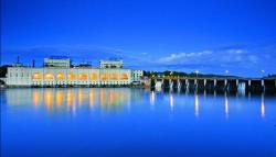
Volkhov, town
VOLKHOV, town. Population: 46,600. Located on both sides of the Volkhov River in its lower course. From the 12th century, there was Mikhailovsky Pogost on the site of V. (the 1500 Novgorod scribe roll mentions Archangel Michael’s Church), which,... more
|
|
|
|
hidden
|
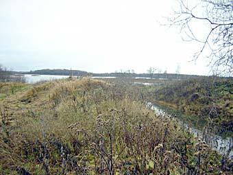
Water - marsh lands
The water - marsh lands (WML; the Ramsar sites is the name of the Ramsarskiye lands(ugodya) in the international classification) . They were founded to protect the waterfowl habitat. The list of 35 lands was registered with the Government... more
|
|
|