|
hidden
|
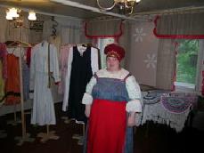
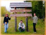
Centre of the Veps folklore, the
The Centre of the Veps folklore (Vinnitsi Village, Podporozhsky District) was made in the local culture house. It is situated in the two-storeyed wooden building. The tasks of the Centre of the Veps folklore are keeping the Veps language and... more
|
|
|
|
hidden
|
Children Art Schools
CHILDREN’S ARTS SCHOOLS (CAS). In the last years Children’s Musical Schools (CMS) and Children’s Painting Schools (CPS) have had a growing tendency for unification into Children’s Arts Schools (CAS). By 2007 the Leningrad oblast had had 104 CAS,... more
|
|
|
|
hidden
|
Eparhy of Olonets and Kargopol
The Eparchy of Olonets and Kargopol. Othodox monasteries and churches of the Olonets region (the territories of present-day Korelia, partly of the Vologda and Leningrad Regions) were originally included into the Eparchy of Novgorod. The foundation... more
|
|
|
hidden
|
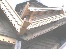
Façade carving
FAÇADE CARVING. With the development of peasant woden architecture, woodcarving also developed. Carving was used for decoration of spouts under the roof. Carving (at first blind carving, in the end of the XIX c. – carving with holes) was also used... more
|
|
|
|
hidden
|
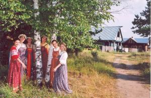
Folk art
AMATEUR AND FOLK ARTS. There are about 50 Amateur and Folk Arts Centres in the Leningrad Oblast, including Amateur Talent Centres (theatrical, musical and ethnographical amateur groups), Arts and Crafts Centres. About 2600 amateur and folk arts... more
|
|
|
|
hidden
|
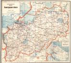
Leningrad Oblast, the
LENINGRAD OBLAST, subject territory of RF. Area: 83,900 sq. Km (max. Extension from west to east: 446 km, north to south: 325 km.) Population (as of 2002): 1,669,000. The Oblast borders Pskov and Novgorod Oblasts in the south, Vologda Oblast in the... more
|
|
|
|
hidden
|
Lodeynoye Pole District
LODEYNOYE POLE DISTRICT, a part of Leningrad Oblast located east of Lake Ladoga in the Svir River basin. In the north-west and north, it borders Olonets District of the Republic of Karelia; in the north-east and east, Podporozhye District; in the... more
|
|
|
|
hidden
|
Municipal Unions
MUNICIPAL ENTITIES, urban or rural (may comprise several united rural localities, such as a volost in Leningrad Oblast) – a settlement, municipal district, or urban area (and an intra-city area of a federal level city), where local government is... more
|
|
|
hidden
|
Natural monuments
The natural monument is the category of the specially protected natural areas and in the international classification they have status of the natural monument. They are a small area, which include important natural objects (terrain feature, groves... more
|
|
|
|
hidden
|
Nikolsky, urban settlement
NIKOLSKY, an urban settlement in the north-west of Podporozhye District. Population: 2,900. It is situated on a peninsula formed by a sharp bend of the Svir River. The name probably originates from the church of St. Nicholas the Miracle Worker... more
|
|
|
hidden
|
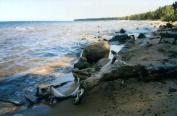
Onega Lake
LAKE ONEGA (Onezhskoye Ozero), located in the north of Russia’s European part within the Republic of Karelia, Vologda Oblast (southern and south-eastern part) and Leningrad Oblast (south-western part.) The L. O. boast belongs to the north-eastern... more
|
|
|
|
hidden
|
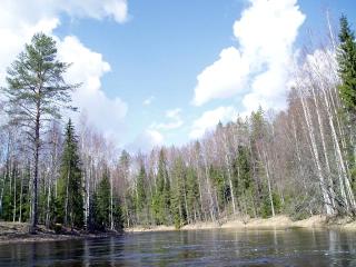
Oyat River, the
OYAT, river, left-hand tributary of the Svir River. Length: 266 km. The average flow rate in the mouth is 54.8 cu. m/s, catchment area: 5220 sq. km. Its source is Lake Chaimozero on the Veps Hills (in Vologda Oblast, 7 km away from the Leningrad... more
|
|
|
|
hidden
|
Podporozgye Museum of the Local Lore and History,
The Podporozgye Museum of the Local Lore and History, a branch of "The Museum Agency" (Podporozhye Town, 1 Isakov Street). "The Spot of the Svir River Region History" was established on the basis of the local lore and history club of the Community... more
|
|
|
|
hidden
|
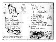
Podporozhye District coat of arms and flag, the
The Podporozhye District's coat of arms and flag are approved officially with the decision of the Representative Assembly of the Municipal Union “Podporozhskiy rayon” (The Podporozhye District) of 21 April 2004, No. 152 and No. 153. The heraldic... more
|
|
|
|
hidden
|
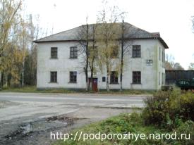
Podporozhye, town
PODPOROZHYE, town, adm. center of Podporozhye District. It is situated 285 km (280 km by railway) north-east of St. Petersburg, on the Svir River. Population: 20,300. The town’s name is related to the rapids on the Svir. The Lodeynoye Pole-Vytegra... more
|
|
|
|
hidden
|
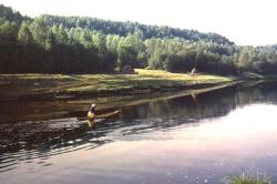
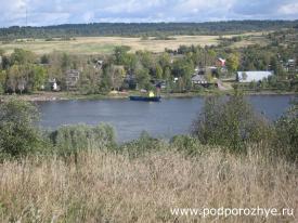
Svir River, the
SVIR, a river in the north-east of Leningrad Oblast. Length: 224 km. Average flow rate at the mouth: 780 cu. m/s, catchment area: 84,400 sq. km. It flows from Lake Onega at its south-western end, crosses Podporozhye and Lodeynoye Pole Districts, and... more
|
|
|
|
hidden
|
Tikhvin District
TIKHVIN DISTRICT, municipal entity. Population: 14,600. Area: 6997.5 sq. km. Adm. center: Tikhvin Town. The district comprises 198 rural localities united into 8 rural settlements. It is located in the east and south-east of Leningrad Oblast. It... more
|
|
|
|
hidden
|
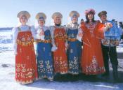
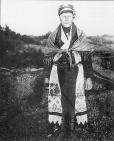
Veps
Veps (IN FORMER TIMES - Chud (Chudes), Chukhars, Kaivans; Veps' native names in the Leningrad Oblast are Vepsya/Bepsya/Veps, Vepslyayzhet/Vepslaazhed/Bepslaazhed, Lyudinikad, Chukharid) are an ethnic community. The Veps language is related to the... more
|
|
|
|
hidden
|
"Vepssky Les" ("Veps Forest"), a park
Vepssky Les ("Veps Forest") is a state natural park. It is located in the territory of the Podporozhie, Tihvin, Boksitogorsk, Lodetnoy Pole districts. It occupies the area of 189,1 thousand hectares. It was founded with resolution of the Governor of... more
|
|
|
|
hidden
|
Verkhniye Mandrogi, village
VERKHNIYE MANDROGI, a village in Podporozhye District. Population: 403. The name’s origin is related to the Karelian words “mandere” = mainland, land, coast, or forest on a bedrock shore, and “jogi” = river. It is located on the right bank of the... more
|
|
|
|
hidden
|
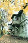
Wooden architecture
Wooden architecture. In the east and north-east of the Leningrad Oblast (Boksitogorsk, Podporozhye, Lodeynoye Pole districts) there are many preserved wooden building that are typical for the Russian North: izbas (Russian traditional wooden peasant... more
|
|
|
|
hidden
|
|
hidden
|
|
hidden
|
|
hidden
|
|
hidden
|
|
hidden
|
|
hidden
|