|
hidden
|
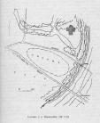
Ancient settlements (selishche)
Selishches, remains of unfortified settlements, discovering according to the presence of the culture lay and withdrawn material. The search of ancient settlements is embarrassed for lack of external indications. More then 120 ancient settlements... more
|
|
|
|
hidden
|
Archaeological monuments
Archaeological monuments of the Leningrad Oblast are settlements, grads, burial grounds, religious objects and other material trails of the past. Settling the oblast territory took place during the Mesolithic period. The age of the most ancient... more
|
|
|
|
hidden
|
Ayramoiset, an ethnic group of Ingermanlandia Finns
The Ayramoiset (Ayramoiset, Evremeisy, Evrimeisy) is an ethnic group of the Finns of Ingermanlandia. Descendants of the migrants of the 17th century to Ingermanlandia from the region of Euryapyae on the Karelian Isthmus. The Ayramoiset kept archaic... more
|
|
|
hidden
|
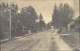
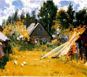
Bolshaya Vruda, village
BOLSHAYA VRUDA, a village in Volosovo District. Population: 2,100. It situated in the upper reaches of the Vruda River (right-hand tributary of the Luga), on the Volosovo-Opolye Highway south-west of Vruda railway station of the Gatchina-Ivangorod... more
|
|
|
|
hidden
|
Bolshoy Sabsk, village
BOLSHOY SABSK, a village in Volosovo District. Population: 1300. It situated at the point of the Saba River flowing into the Luga on the Moloskovitsi-Osmino Highway. The toponym Saba is of Baltic Finnish origin, from Estonian saba = “tail” or... more
|
|
|
|
hidden
|
Bolshoye Kuzyomkino, village
BOLSHOYE KUZYOMKINO (Finnish Narvusi), a village in Kingisepp District. Population: 961. It situated at the confluence of the Mertvitsa and the Luga. It was first mentioned in Swedish sources in 1614 (in July 2004, the 390th anniversary of its... more
|
|
|
|
hidden
|
Colonists (immigrants in Tsar Russia)
Colonists are a class group existed in the 18th - the early 20th century. Catherine II promulgated manifestoes (dated 4 December 1762 and 22 July 1763) allowed to foreigners to settle in Russia for rapid settlement of lands and development of... more
|
|
|
hidden
|
Culture of Mounds
The Culture of Mounds. Mounds are high steep-side hills with the flat top and with the circle made of boulders at the foot. The area of the mound culture include basins of Ilmen Lake, the Msta, Volkhov, Luga rivers. There are mounds in the Luga,... more
|
|
|
|
hidden
|
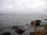
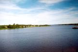
Gulf of Finland, the
GULF OF FINLAND, in the eastern part of the Baltic Sea. Area: about 29,800 sq. km (7% of the Baltic Sea area.) Length: 400 km (from the Khanko Peninsula to SPb.) Max. width: 130 km (near the western border of Leningrad Oblast, at the meridian of... more
|
|
|
|
hidden
|
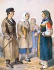
Izhora (Izhora men)
Izhora (Izhoras, the own native name is Izurit) is an ethnic community. Their language is related to the Baltic-Finnic subgroup of the Finno-Ugric branch of the Uralic language family. Accorging to the most widespread version the Izhora separated... more
|
|
|
|
hidden
|
Kingisepp District
KINGISEPP DISTRICT, a part of Leningrad Oblast. Population: 74,300, of which, 52,100 live in the adm. center Kingisepp Town. Area: 2842.1 sq. km. It has 191 rural settlements. It was established in 1927.It borders with Lomonosov, Volosovo, and... more
|
|
|
|
hidden
|
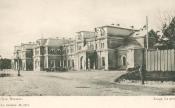
Kingisepp Museum od the Local History, the
The Kingisepp Museum od the Local History (Kingisepp Town, 1 Karl Marks Prospekt). The museum was founded on November 5, 1960 фссщквштп the initiative of the Public Soviet. D.I. Smolsky, one of the Public Soviet leaders, became the first manager... more
|
|
|
|
hidden
|
Kingisepp, town
KINGISEPP, town, adm. center of Kingisepp District. Population: 50,300. It situated on the banks of the Luga River, at the St. Petersburg-Tallinn highway and the St. Petersburg-Ivangorod-Tallinn railroad. The municipal entity Kingisepp Urban... more
|
|
|
|
hidden
|
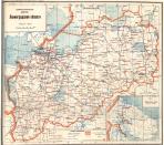
Leningrad Oblast, the
LENINGRAD OBLAST, subject territory of RF. Area: 83,900 sq. Km (max. Extension from west to east: 446 km, north to south: 325 km.) Population (as of 2002): 1,669,000. The Oblast borders Pskov and Novgorod Oblasts in the south, Vologda Oblast in the... more
|
|
|
|
hidden
|
Luga District
LUGA DISTRICT, municipal entity. Population: 44,600. Area: 5993.1 sq. km. Located in the south of Leningrad Oblast. In the west, it borders Slantsy District, in the north, Volosovo, Gatchina, and Tosno Districts of Leningrad Oblast; in the east,... more
|
|
|
|
hidden
|
Luga District coat of arms, the
The Luga District's coat of arms is the official symbol of the Municipal Union “Luzhskiy rayon” (The Luga District) that was approved with the decision of the District’s Deputy Assembly of the Municipal Union “Luzhsky rayon” (The Luga District) of ... more
|
|
|
|
hidden
|
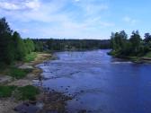
Luga, town
LUGA, town, adm. center of Luga District. Located 142 km (139 by railway) south of St. Petersburg on the Luga River, after which it was given its name. Population: 40,400. The town is a junction of motor and railroad routes to St. Petersburg,... more
|
|
|
|
hidden
|
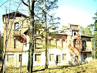
Marienhof, a country estate
Marienhof, a country estate in the Kingisepp distrct. The land at the emptying of the River Solka into the River Luga. The land was named Terpigorye and was the family estate of General-Anshef Barony F.-B. Bleken, his ancestors owned the land in the... more
|
|
|
|
hidden
|
Narova River, the
NAROVA (Narva, obsolete Estonian Alukse), river. Length: 77 km. Catchment area: 56,200 sq. km. Flow rate: 399 cu. m/s. It flows out of Lake Chudskoye and it flows into the Narva Bay of the Baltic Sea. N. is a borderline between Russian Federation... more
|
|
|
|
hidden
|
Oredezh River, the
OREDEZH, river, right-hand tributary of the Luga River. Length: 192 km. Catchment area: 3,200 sq. km. Flow rate: 20 cu. m/s. It originates from the springs on the southern slope of the Izhora Hills, in the Dontso tract. It flows across Volosovo,... more
|
|
|
|
hidden
|
Plyussa River, the
PLYUSSA, river. Flows in Pskov Oblast and in Slantsi District of Leningrad Oblast. Length: 281 (according to other data, 295) km. Catchment area: 6,500 sq. km. Flow rate: 50 cu. m/s. It flows out of Lake Zaplyusye (Zaimosskoye) and into the Narva... more
|
|
|
|
hidden
|
Pogosts
POGOSTS, a term widely used in the 10th – 18th centuries to designate territorial divisions and settlements; its meaning changed with time. P. was the term for the centers of rural communities that paid tribute to the Prince; place of tribute ... more
|
|
|
hidden
|
Preobrazhenskoye, a country estate
Preobrazhenskoye, a country estate (the village of Preobrazhenka, the Kingisepp district). In 1797 Paul I granted villages of Novaya and Ostrov, located in the River Luga lower reach, to Colonel Ye.K. Renne. In 1841 his widow sold the estate yo... more
|
|
|
|
hidden
|
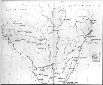
Pyatinas
PYATINAS, adm. and territorial regions of the core Novgorod Land as part of a united Russian State in the late 15th – 17th century. They are known from written sources (scribe rolls and deeds) from the late 15th century. There were five P.... more
|
|
|
|
hidden
|
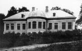
Sabsk Museum of the Local History, the
The Sabsk Museum of the Local History (the village of Bolshy Sabsk, the Volosovo district) was founded on 11 November 1981. It got the status of the people's museum in 1991. The museum is placed at the Community Centre. Exhibits told about the... more
|
|
|
|
hidden
|
Sala, a country estate
Sala, a country estate (the village of Sala, the Kingisepp district). In the middle of the 18th century the village of Sala was the centre of the estate of Terpigorye that belonged to General F.-V. Bleken. In 1764 his daughter Sh.-M. Korf became the... more
|
|
|
|
hidden
|
Slantsi District
SLANTSY DISTRICT, a part of Leningrad Oblast. Population: 2,200 sq. km. Population: 47,900. S. D. comprises Slantsy Town (adm. center) and 155 rural localities. It borders Kingisepp, Volosovo, and Luga Districts of Leningrad Oblast, Gdov District... more
|
|
|
|
hidden
|
Slantsi, town
SLANTSI, town, adm. center of Slantsi District. Population: 47,900. It is situated on the Plyussa River at the railway station of the same name of the St. Petersburg-Gdov railway branch (opened in 1940.) In 1926, the Gdov (Leningrad) deposit of oil... more
|
|
|
|
hidden
|
The Culture of long burial mounds (barrows)
The Culture of long burial mounds (long barrows). The new culture was extended on the vast territory included Pskov Lake, the Velikaya, Lovat, Msta, Mologa and Chagodoshch (partly) rivers in the middle of AD 1000. This culture is distinguished... more
|
|
|
|
hidden
|
Tolmachevo, urban settlement
TOLMACHEVO, an urban settlement in Luga District. Population: 3,400. It is situated on the banks of the Luga River. The St. Petersburg-Pskov railway and Kiev Highway extend close by. Up to the early 1990s, there was steamboat service from the... more
|
|
|
|
hidden
|
Ust-Luga, settlement
UST-LUGA, a settlement in Kingisepp District. Population: 1990; apart from the Russians, Izhora and Vod families live in U.-L. and its environs. Located in the mouth of the Luga River. Adjacent to U.-L. is Krakolye village. The settlement appeared... more
|
|
|
|
hidden
|
Vodskaya Land
VODSKAYA LAND (Votskaya Land), historic, cultural, and administrative region of the middle-age Rus, located in the north-western part of Veliky Novgorod’s lands (western part of the current Leningrad Oblast.) First mentioned in the chronicle c.... more
|
|
|
hidden
|
Volosovo District
VOLOSOVO DISTRICT, a part of Leningrad Oblast. Area: 2680.5 sq. km. Population: 46,900. Adm. center: Volosovo Town. The district comprises Kikerino urban settlement, and 202 rural localities. It borders Kingisepp, Lomonosov, Gatchina, and Luga... more
|
|
|
|
hidden
|
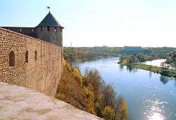
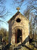
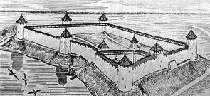
Yamgorod Fortress
Yamgorod Fortress (Kingisepp, in the right bank of the Luga River). The Yam fortress was built in 1384 during 33 days under the direction of Novgorod posadniks. It controlled water and land passes from Novgorod to port towns of Baltic. It repelled... more
|
|
|
|
hidden
|
|
hidden
|
|
hidden
|
|
hidden
|
|
hidden
|
|
hidden
|
|
hidden
|
|
hidden
|
|
hidden
|
|
hidden
|
|
hidden
|