|
hidden
|
Gorkovskoye, settlement
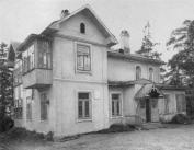
GORKOVSKOYE, a settlement in Vyborg District. Population: 297. It appeared in 1948 as a result of integration of the villages of Neuvola (also Neivola) and Kirjavala. It was named after A. M. Gorky (Peshkov) who lived in Kirjavala village in the... more
|
|
|
|
hidden
|
Gostilitsi, village
GOSTILITSI, a village in Lomonosov District. Population: 3600. It is located at the northern edge of the Izhora Hills, on the Gostilka River. The name originates from the Novgorod name Gostilo. First mention was in Novgorod’s scribe roll of... more
|
|
|
|
hidden
|
Grand Principality of Finland*, v. Finland
reference
|
|
|
hidden
|
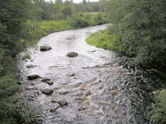
Gromovo, settlement
GROMOVO (Sakkola before 1948), a settlement in Priozersk District. Population: 922.It is located on the shore of Lake Sukhodolskoye (former Suvanto.). Sakkola or Sakkula (according to one of the versions, from the name Zachary/Sakari) was first... more
|
|
|
|
hidden
|
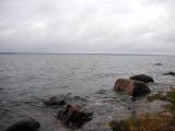
Gulf of Finland, the
GULF OF FINLAND, in the eastern part of the Baltic Sea. Area: about 29,800 sq. km (7% of the Baltic Sea area.) Length: 400 km (from the Khanko Peninsula to SPb.) Max. width: 130 km (near the western border of Leningrad Oblast, at the meridian of... more
|
|
|
|
hidden
|
Highways
HIGHWAYS, hard-surface motor (formerly cart) roads. Russia’s first H. was the Moscow-St. Petersburg route across the territory of today’s Leningrad Oblast built in 1817-1835 (and reconstructed in 1946-61.) Currently, five motor routes of the federal... more
|
|
|
|
hidden
|
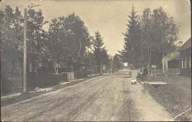
Ilyichovo, settlement
ILYICHOVO (Finnish Jalkala before 1948), a settlement in Vyborg District. Population: 1100. It is located between Lake Krasavitsa and Lake Dolgoye. The toponym Jalkala originates probably from a nickname of the residents (Finnish jalka = leg.) The... more
|
|
|
|
hidden
|
Ingermanland Gubernia*, v. Sankt-Peterburg Gubernia
reference
|
|
|
hidden
|
Ingermanlandia
INGERMANLANDIA (Swed. Ingermanland, Rus. Izhora Land or Ingria), historic and cultural region in the western part of the Leningrad Oblast (Kingisepp, Volosovo, Lomonosov, Vsevolozhsk, Gatchina, Tosno, western part of Kirovsk Districts.) The western... more
|
|
|
|
hidden
|
Iokhannes*, v. Sovetsky, urban settlement
reference
|
|
|
hidden
|
Issad, village
ISSAD (Izsad in the 19th c.), a village in Volkhov District. Population: 1100. It is located on the right bank of the Volkhov River. The Murmansk Highway extends close to I. The name originates from the Old Russian “issad”/”isad” = trade wharf. In... more
|
|
|
|
hidden
|
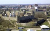
Ivangorod, town
IVANGOROD, a town in Kingisepp District. Population: 11,200. Located at the western border of Leningrad Oblast. Established in1492, when a stone fortress named in honor of Ivan III, Grand Prince of Moscow and All Russia (see Ivangorod Fortress) was... more
|
|
|
|
hidden
|
Izhora River, the
IZHORA, river, left - hand tributary of the Neva River. Total length: 76 km. Basin area: abt. 1,000 sq. km. The river springs from Skvoritsy Village, Gatchina District. It flows across Gatchina and Tosno Districts of the Leningrad Oblast and Kolpino... more
|
|
|
|
hidden
|
Kaarlakhti*, v. Kuznechnoye, urban settlement
reference
|
|
|
hidden
|
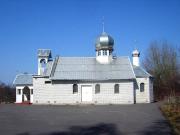
Kamennogorsk, town
KAMENNOGORSK (Antrea before 1948, Swedish Sankt-Andre), a town in Vyborg District. Population: 5,800. It is situated on the bank of the Vuoksa River. Initially, the area of K. belonged to Jaaski Uyezd (see Lesogorsk), split by the Nystad Treaty... more
|
|
|
|
hidden
|
Kauko-Lempeyelya*, v. Tsvelodubovo, settlement
reference
|
|
|
hidden
|
Kaybolovo, village
KAYBOLOVO, a village in Kingisepp District. Population: 75. It is located on the Suma River (north-western part of the Izhora Hills). 2 km west of K., the Kaybolovskoye ancient site was discovered. It is an earthwork dated 2nd half of the 12th to... more
|
|
|
|
hidden
|
Keksgolm*, v. Priozersk, town
reference
|
|
|
hidden
|
Khaapala*, v. Leninskoye, settlement
reference
|
|
|
hidden
|
Khotchino*, v. Gatchina, town
reference
|
|
|
hidden
|
Khumalyioki*, v. Yermilovo, settlement
reference
|
|
|
hidden
|
Kikerino, urban settlement
KIKERINO, an urban settlement in Volosovo District. Population: 2,000. It is situated at the Bolshiye Kolpany-Volosovo road. The name is probably related to the Baltic Finnish last name Kekki (Kekke.) The toponym K. is mentioned in Novgorod’s... more
|
|
|
|
hidden
|
Kingisepp District
KINGISEPP DISTRICT, a part of Leningrad Oblast. Population: 74,300, of which, 52,100 live in the adm. center Kingisepp Town. Area: 2842.1 sq. km. It has 191 rural settlements. It was established in 1927.It borders with Lomonosov, Volosovo, and... more
|
|
|
|
hidden
|
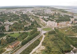
Kingisepp, town
KINGISEPP, town, adm. center of Kingisepp District. Population: 50,300. It situated on the banks of the Luga River, at the St. Petersburg-Tallinn highway and the St. Petersburg-Ivangorod-Tallinn railroad. The municipal entity Kingisepp Urban... more
|
|
|
|
hidden
|
Kipen, village
KIPEN, a village in Lomonosov District. Population: 3100. It is located in the northern part of the Izhora Hills. It is situated at the crossing of roads to Strelna, Volosovo, Gatchina, with the Tallinn Highway close by. The toponym originates from... more
|
|
|
|
hidden
|
Kirishi District
KIRISHI DISTRICT, a part of Leningrad Oblast. Area: 3009 sq. km. Population: 67,700. In the west, it borders Tosno, in the north-west, Kirovsk, in the north, Volkhov, and in the east, Tikhvin Districts of Leningrad Oblast; in the south-east, with... more
|
|
|
|
hidden
|
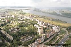
Kirishi, town
KIRISHI, town, adm. center of Kirishi District. It is situated at the crossing of the Mga-Pestovo and Volkhovstroy-Chudovo railway lines. Motor roads connect K. to the Novaya Ladoga-Murmansk and St. Petersburg-Moscow routes. The name is related to... more
|
|
|
|
hidden
|
Kirovsk District
KIROVSK DISTRICT, a part of Leningrad Oblast. Area: 2590.9 sq. km. Population: 97,000. Located in the central part of Leningrad Oblast. In the north, it borders the Lake Ladoga coast; in the north-west and west, Vsevolozhsk District, in the west,... more
|
|
|
|
hidden
|
Kirovsk, town
KIROVSK, town, adm. center of Kirovsk District. Population: 25,400. It is situated on the left bank of the Neva. The town extends along the bank for more than 5 km, and has a quay. The “Kola” highway is 5 km south of K.; the town is connected with... more
|
|
|
|
hidden
|
Kiselnya, village
KISELNYA, a village in Volkhov District. Population: 1764. The name may be related to the Yelena River beginning in the environs of the village. K. is located at the point of crossing of several motor roads of local importance and the St.... more
|
|
|