|
hidden
|
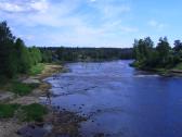
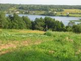
Sestra River, the
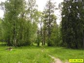
SESTRA (Swedish Systerback, Finnish Rajajoki / “Frontier River”), a river in Vsevolozhsk and Vyborg Districts of Leningrad Oblast and in St. Petersburg. Length: 74 km. Depth: up to 3 m (in the mouth.) Catchment area: 393 sq. km. It begins in a marsh... more
|
|
|
|
hidden
|
Shapki, settlement
SHAPKI, a settlement in Tosno District. Population: 549. Located at Shapki railway station (branch connecting the settlement to Tosno Town.) Located at the Shapki Heights (their shapes remind caps, “shapki”, therefore the name) – kame hills reaching... more
|
|
|
|
hidden
|
Shugozero, settlement
SHUGOZERO, a settlement in Tikhvin District. Population: 2423. Located on the southern shore of Lake Sredneye. The name originates from the neighboring large lake, Shugozero. The settlement is connected by a motor road to Tikhvin Town and localities... more
|
|
|
|
hidden
|
Sinyavino, urban settlement
SINYAVINO, an urban settlement in Kirovsk District. Population: 3,600. Administratively subordinate to S. is Sinyavino-– settlement located 10 km east of the basic settlement. The name is related to the family name of the Russian admirals Sinyavin... more
|
|
|
|
hidden
|
Siversky, urban settlement
SIVERSKY, an urban settlement in Gatchina District. Population: 12,100. It is situated on the right bank of the Oredezh River. The name originates from Seversko Staroye and Seversko Novoye villages mentioned in Novgorod’s 1499 scribe roll.... more
|
|
|
|
hidden
|
Slantsi District
SLANTSY DISTRICT, a part of Leningrad Oblast. Population: 2,200 sq. km. Population: 47,900. S. D. comprises Slantsy Town (adm. center) and 155 rural localities. It borders Kingisepp, Volosovo, and Luga Districts of Leningrad Oblast, Gdov District... more
|
|
|
|
hidden
|
Slantsi, town
SLANTSI, town, adm. center of Slantsi District. Population: 47,900. It is situated on the Plyussa River at the railway station of the same name of the St. Petersburg-Gdov railway branch (opened in 1940.) In 1926, the Gdov (Leningrad) deposit of oil... more
|
|
|
|
hidden
|
Slavyanka River, the
SLAVYANKA, a river in Gatchina District of Leningrad Oblast and in St. Petersburg, left-hand tributary of the Neva. Length: 39 km. Catchment area: 249 sq. km. Flow rate: 1.8 cu. m/s. It originates from the Taytsi Springs on the Pyazelevsky Hills... more
|
|
|
|
hidden
|
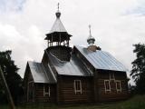
Sologubovka, settlement
SOLOGUBOVKA, a village in Kirovsk District. Population: 361. Located on the right bank of the Mga River. North-east of S. is the railway station of the same name of the Mga-Kirishi line (opened in 1919). In the 19th c. it was the Uspenskaya estate.... more
|
|
|
|
hidden
|
Somino, Village
SOMINO, a village in Boksitogorsk District. Population: 383. According to a legend, the name originates from the Sominka River where Peter I caught “som”, a catfish. More probable is the toponym’s origin in the Baltic Finnish “so” = marsh, knowing... more
|
|
|
|
hidden
|
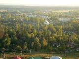
Sosnovo, settlement
SOSNOVO (Finnish Rautu before 1948), a settlement in Priozersk District. Population: 6000. Located south of Lake Razdolinskoye (Finnish Leihinkylanjarvi) at Sosnovo railway station of the St. Petersburg-Priozersk branch. The toponym Rautu originates... more
|
|
|
|
hidden
|
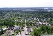
Sosnovy Bor, town
SOSNOVY BOR, a town in Leningrad Oblast. Population: 66,100. It is located on the shore of the Koporye Bay of the Gulf of Finland, in the mouth of the Kovasha River, near Kalische Railway Station (St. Petersburg-Ust-Luga line.) The town was built on... more
|
|
|
|
hidden
|
Sovetsky, urban settlement
SOVETSKY (Johannes [Finnish] before 1948), an urban settlement in Vyborg District. Population: 6,600. It is situated on the coast of the Gulf of Finland. The name Johannes is related to the Lutheran parish of St. Johannes (known from the 17th c.; a... more
|
|
|
|
hidden
|
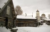
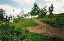
Staraya Ladoga, Village
STARAYA LADOGA (Ladoga before 1704), a village in Volkhov District. Population: 2200. Located on the left bank of the Volkhov River where the Ladozhka (Yelena) River flows into it. The toponym is of a Baltic Finnish origin, from Alodejogi (lower... more
|
|
|
|
hidden
|
Susanino, settlement
SUSANINO, a settlement in Gatchina District. Population: 2200. Located at the railway station of the same name of the St. Petersburg-Oredezh branch. The settlement appeared in the early 1900s in the place of Malaya Kovshovka village, when local... more
|
|
|
|
hidden
|
Suyda River, the
SUYDA (Suydinka), a river in Gatchina District. Length: 63 km. Catchment area: 475 sq. km. Flow rate: 3.1 cu. m/s. Its source is in a marsh north-west of Tikhkovitsi village. It is a karst river. It flows among fields and meadows, with its banks... more
|
|
|
|
hidden
|
Svetogorsk, town
SVETOGORSK (Enso [Finnish] before1948), a town in Vyborg District; a separate municipal entity in 1995–2005. Population: 15,700. Located in the northern part of the Karelian Isthmus near the Finnish border, on the banks of the Vuoksa River. S. has... more
|
|
|
|
hidden
|
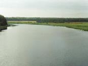
Svir River, the
SVIR, a river in the north-east of Leningrad Oblast. Length: 224 km. Average flow rate at the mouth: 780 cu. m/s, catchment area: 84,400 sq. km. It flows from Lake Onega at its south-western end, crosses Podporozhye and Lodeynoye Pole Districts, and... more
|
|
|
|
hidden
|
Svirstroy, urban settlement
SVIRSTROY, an urban settlement in Lodeynoye Pole District. Population: 1,000. It is situated on the left bank of the Svir River. S. has transport communications to Lodeynoye Pole and Podporozhye via the Svir and a motor road and railroad; 5 km... more
|
|
|
|
hidden
|
Syas Canals , the
SYAS CANALS. They connect the mouths of the Volkhov and Syas Rivers, and extend along the south-eastern coast of Lake Ladoga, being an extension of the Ladoga Canals. Currently they are in Volkhov District, from Nemyatovo village to Syasstroy town.... more
|
|
|
hidden
|
Syas River, the
SYAS, a river in the south-eastern Priladozhye. Length: 260 km, of which, abt. 190 km within Leningrad Oblast. The average flow rate is 61.6 cu. m/s, and the catchment area, 7330 sq. km. It originates in the north-east of Novgorod Oblast, 6 km... more
|
|
|
|
hidden
|
Syasstroy, town
SYASSTROY, a town in Volkhov District. Population: 13,700. It situated in the lower reach of the Syas River, where the Valgomka flows into it. The etymology of the name is typical for settlements attached to industrial facilities erected in the... more
|
|
|
|
hidden
|
Taytsi, urban settlement
TAYTSI, an urban settlement in Gatchina District. Population: 2,600. It is situated at Taytsi railway station of the St. Petersburg-Gatchina Baltiyskaya branch. The settlement was established in 1960. There are also the villages of Bolshiye Taytsi... more
|
|
|
|
hidden
|
Tervenichi, village
TERVENICHI, a village in Lodeynoye Pole District. Population: 409. Located on the western shore of Lake Pogostskoye. The Veps name for the village is Terl (from the Old Veps name Terv; the current Veps “terv” = tar.) The village has access to the... more
|
|
|
|
hidden
|
Tigoda River, the
TIGODA, river, left-hand tributary of the Volkhov. Length: 143 km, average flow rate: 4.21 cu. m/s, catchment area: 589 sq. km. It originates among the bogs in the extreme south of Tosno District north-east of Ogorelye railway station. In its upper... more
|
|
|
|
hidden
|
Tikhvin Canal System
TIKHVIN CANAL SYSTEM, a traffic artery in the north-west of European Russia. It connected the basins of the Baltic Sea and the Volga in the 19th-20th cc. It began at the city of Rybinsk on the Volga (later at the Rybinsk Reservoir), extended via the... more
|
|
|
|
hidden
|
Tikhvin District
TIKHVIN DISTRICT, municipal entity. Population: 14,600. Area: 6997.5 sq. km. Adm. center: Tikhvin Town. The district comprises 198 rural localities united into 8 rural settlements. It is located in the east and south-east of Leningrad Oblast. It... more
|
|
|
|
hidden
|
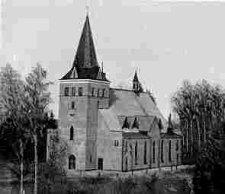
Tikhvin, town
TIKHVIN, town, adm. center of Tikhvin District. It is situated on the Tikhvinka River. Population: 63,300. Close to T. is the Novaya Ladoga-Yaroslavl highway. Within the town lines there is Tikhvin railway station on the St. Petersburg-Vologda... more
|
|
|
|
hidden
|
Tikhvinka River, the
TIKHVINKA, river, right-hand tributary of the Syas River. Length: 155 km. Average flow rate: 19.9 cu. m3/s. It originates from Lake Krupino in Boksitogorsk District, 5 km north of Yefimovsky urban settlement, and flows in the latitudinal direction... more
|
|
|
|
hidden
|
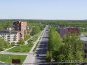
Toksovo, urban settlement
TOKSOVO, an urban settlement in Vsevolozhsk District. Population: 5,900. In 1920-49, it was a district center (before 1936, the adm. center of a Finnish ethnic district.) The toponym Toksovo (Finnish “Toksova”) is of a Baltic Finnish origin, and... more
|
|
|